Mount Rinjani’s Hidden Route The Journey from Segara Anak Lake to Senaru Crater Rim (Sangkareang Second Summit)
Towering above the island of Lombok, Mount Rinjani continues to attract adventurers from around the world with its dramatic volcanic landscapes, breathtaking crater lake, and unforgettable trekking routes. While many hikers focus on reaching the main summit via Sembalun, experienced trekkers often describe another route as one of the most rewarding experiences on the mountain — the challenging climb from Segara Anak Lake to Senaru Crater Rim, widely known among local guides as the journey toward Sangkareang, the “Second Summit” of Rinjani.
This trail is not simply a connector between campsites. It is a complete wilderness experience filled with steep volcanic terrain, dense mountain forest, panoramic caldera views, and one of the most scenic camping locations in Indonesia. For many trekkers, this section becomes the emotional highlight of the entire Mount Rinjani expedition.
Discovering the Heart of Mount Rinjani
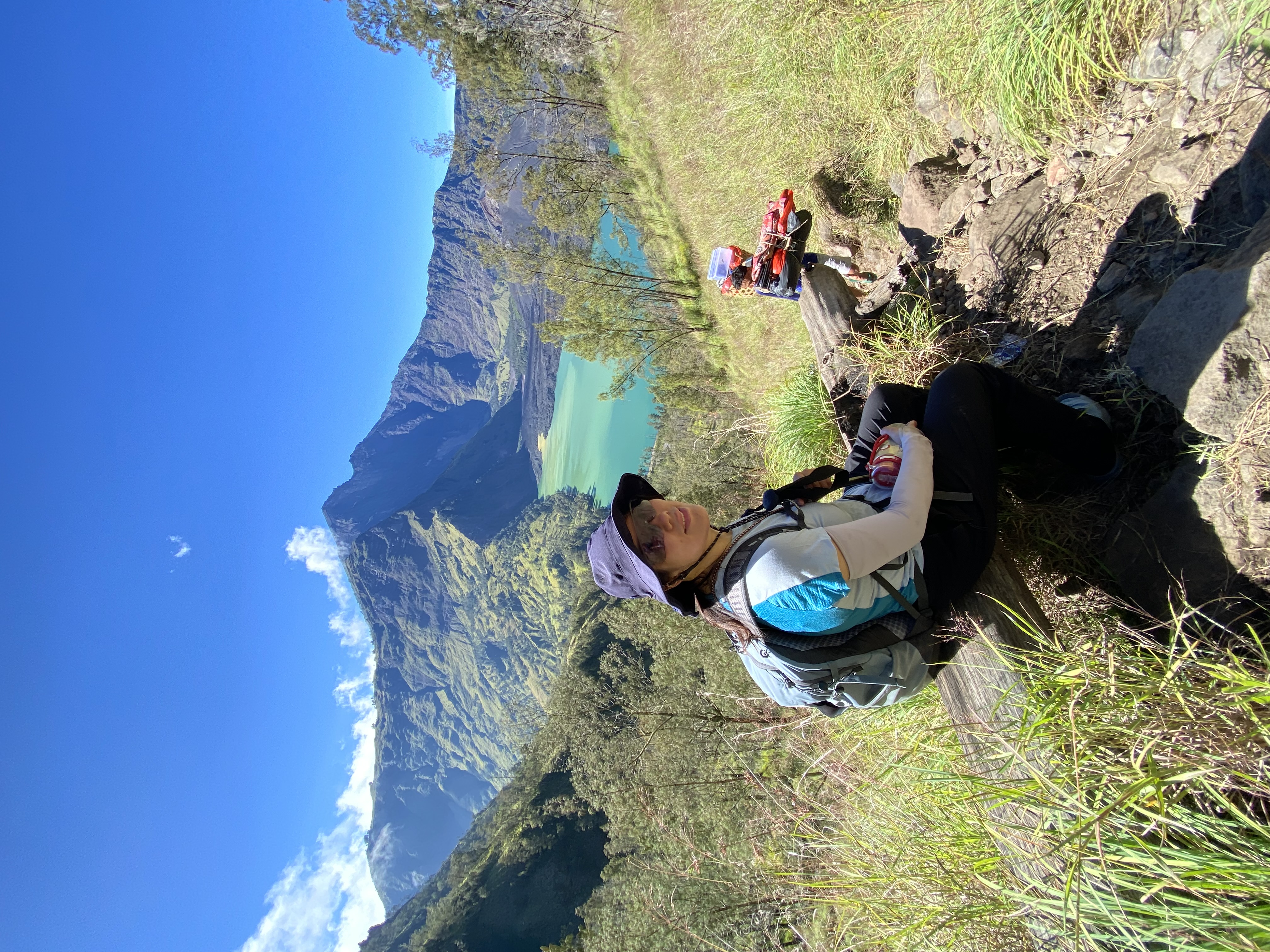
Located inside the massive caldera of Mount Rinjani lies Segara Anak Lake, a deep blue volcanic lake sitting approximately 2,000 meters above sea level. The name “Segara Anak” translates to “Child of the Sea,” inspired by the lake’s ocean-like blue color and calm atmosphere surrounded by towering crater walls.
After spending a night beside the lake, many trekkers continue their journey upward toward Senaru Crater Rim. This route is famous for its long ascent and physically demanding terrain, yet it rewards hikers with some of the most dramatic views found anywhere on Mount Rinjani.
The Senaru Crater Rim stands at approximately 2,641 meters above sea level and overlooks the entire crater system. From here, hikers can see Segara Anak Lake below, the active volcanic cone of Barujari rising from the center of the lake, the tropical forests of North Lombok, and even the coastline stretching toward the Bali Sea on clear days.
Among local trekking communities, this viewpoint is often referred to as Sangkareang Second Summit because of its elevated perspective and extraordinary panoramic scenery. Although it is not the official highest peak of Rinjani, many trekkers consider the visual experience equally spectacular.
Trail Overview: Segara Anak Lake to Senaru Crater Rim
Starting Point
- Segara Anak Lake
- Approximate elevation: 2,000 meters
Ending Point
- Senaru Crater Rim / Sangkareang
- Approximate elevation: 2,641 meters
Trekking Duration
- Around 3 to 5 hours
- Depending on weather conditions and trekking pace
Difficulty Level
- Moderate to difficult
- Recommended for trekkers with good stamina and hiking experience
Terrain Characteristics
- Continuous uphill climb
- Rocky volcanic pathways
- Forest sections with exposed roots
- Narrow trails along the caldera wall
- Open ridges with steep drop-offs and panoramic viewpoints
Unlike the summit trail from Sembalun, which consists mainly of loose volcanic sand, the Senaru ascent combines tropical forest terrain with rocky switchbacks and steep ridgeline trekking. This variety makes the trail feel more adventurous and less repetitive.
The Climb Through the Caldera Wall
The trek usually begins early in the morning from the lakeside camp. The first section immediately introduces hikers to steep inclines through rocky volcanic paths. Trekkers slowly ascend the massive caldera wall that surrounds Segara Anak Lake.
As the altitude increases, the lake gradually reveals its full shape below. Morning clouds often drift through the valley while sunlight illuminates the crater cliffs, creating one of the most photogenic moments on the mountain.
Several resting points along the route allow hikers to catch their breath while enjoying extraordinary scenery. Unlike crowded summit routes during peak season, this trail often feels quieter and more peaceful, offering a deeper connection with nature.
The final approach to Senaru Crater Rim becomes steeper, but once hikers reach the top, the reward is immediate: a wide-open panorama stretching across the entire national park.
Why Sangkareang is Called the “Second Summit”
Although Mount Rinjani’s official summit stands at 3,726 meters, many guides and trekkers affectionately refer to Senaru Crater Rim as the “Second Summit” due to its unmatched panoramic position.
From Sangkareang, hikers can witness:
- The complete view of Segara Anak Lake
- Mount Barujari volcano inside the crater
- The northern forests of Lombok
- Sunset above the clouds
- Sunrise illuminating the volcanic caldera
- Views extending toward Bali and the Gili Islands during clear weather
Unlike the main summit, which focuses on reaching the highest point, Sangkareang offers a more relaxed and immersive mountain experience. Many trekkers say this campsite feels more spiritual, peaceful, and visually dramatic than the summit itself.
Camping Experience at Senaru Crater Rim
Camping at Senaru Crater Rim is considered one of the highlights of the Rinjani trekking experience. The campsite sits directly on the edge of the caldera, providing uninterrupted views throughout the day and night.
During sunset, the entire crater glows with orange and golden light while clouds move beneath the cliffs. At night, the sky often becomes filled with stars, and the sounds of nature create an unforgettable wilderness atmosphere.
Temperatures can become quite cold due to strong mountain winds, especially between June and August. Proper trekking equipment and warm clothing are highly recommended.
Wildlife and Natural Environment
The Senaru route passes through sections of tropical mountain forest rich in biodiversity. Trekkers occasionally encounter:
- Long-tailed monkeys
- Exotic mountain birds
- Tropical vegetation and giant trees
- Volcanic rock formations shaped by past eruptions
Because the trail lies inside Mount Rinjani National Park, conservation efforts are extremely important. Responsible trekking practices such as carrying out trash and respecting wildlife help preserve the ecosystem for future generations.
Best Time to Trek the Route
The ideal trekking season for Mount Rinjani typically runs from:
- April to November
During these months:
- Trails are generally dry
- Visibility is clearer
- Camping conditions are safer
- Sunrise and sunset views are more consistent
The national park usually closes during the peak rainy season for safety and environmental recovery.
Essential Trekking Tips
Start Early from the Lake
Morning temperatures are cooler and weather conditions are usually more stable.
Bring Enough Drinking Water
The climb is physically demanding and dehydration can occur quickly.
Use Proper Trekking Shoes
The rocky terrain and steep inclines require strong grip and ankle support.
Carry Warm Clothing
Evenings at Senaru Crater Rim can become extremely cold due to altitude and wind exposure.
Hire Experienced Local Guides
Professional guides help ensure safety, navigation, campsite preparation, and environmental responsibility.
Popular Trekking Programs Including This Route
The Segara Anak to Senaru Crater Rim section is commonly included in:
- 3 Days 2 Nights Sembalun Summit Lake Senaru Trek
- 4 Days 3 Nights Rinjani Exploration Trek
- Private Mount Rinjani Trekking Packages
- Shared Group Trekking Programs
Most trekking packages include:
- Licensed trekking guide
- Porter service
- Camping equipment
- Meals during the trek
- National park entrance ticket
- Transportation in Lombok
A Journey Beyond the Summit
For many hikers, the true beauty of Mount Rinjani is not only about reaching the highest point but about experiencing the diverse landscapes hidden throughout the volcano itself. The journey from Segara Anak Lake to Senaru Crater Rim represents this perfectly — a trail where challenge, silence, nature, and breathtaking scenery come together in one unforgettable adventure.
Sangkareang Second Summit remains one of the most underrated viewpoints on Mount Rinjani, offering trekkers a deeper appreciation of Lombok’s volcanic wilderness and the raw beauty of Indonesia’s most iconic mountain landscape.
0 Comments